
Trail Map
8 trails. 40 vertical feet. One rope tow. All the skiing you need.
Tabor Run Mountain
Lodge/Summit: 390 ft
Base: 350 ft
Vertical: ~40 ft
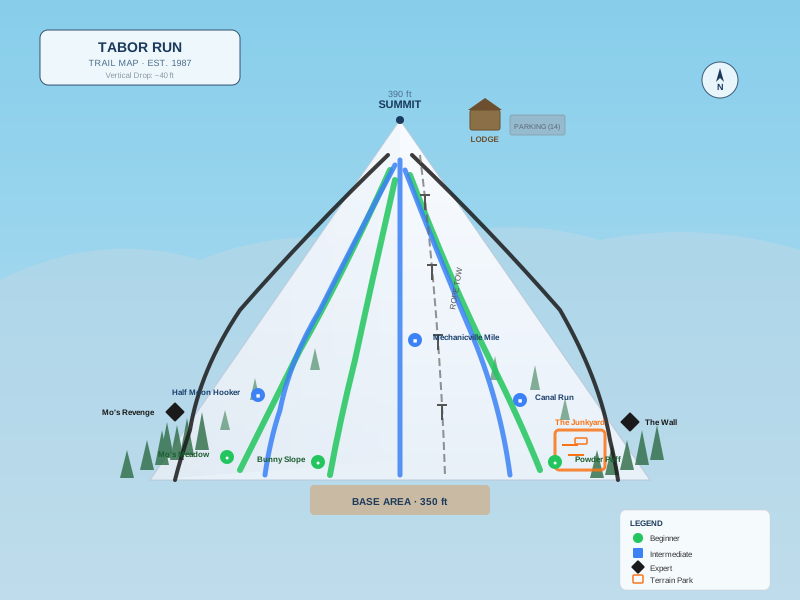
Trail Guide
●
Beginner
- Mo's Meadow — The original run, carved by Mo himself
- The Bunny Slope — It's exactly what it sounds like
- Powder Puff — Gentle grade, wide open
■
Intermediate
- Half Moon Hooker — Named after the town, not the turn
- The Mechanicville Mile — Not actually a mile. More like 400 feet.
- Canal Run — Inspired by the nearby Erie Canal. Similarly flat.
◆
Expert
- Mo's Revenge — The steepest 12 feet in Saratoga County
- The Wall — Locals call it The Wall. Visitors call it "a mild slope."
▲
Terrain Park
- The Junkyard — Two rails and a box Mo welded in 1994
Mountain Info
Lift
Main Rope Tow — Our state-of-the-art vertical transportation system — a rope connected to the winch on Mo's Land Rover — carries skiers from the base (350 ft) back up to the lodge and summit (390 ft) in approximately 45 seconds. Gloves required. Seriously, bring gloves.
Skiable Terrain
~5
Skiable Acres
~40 ft
Vertical Drop
390 ft
Summit Elevation
~15%
Average Grade
Difficulty Breakdown
Beginner 38%
Intermediate 38%
Expert 25%
Trail map illustration is for reference only. Actual terrain may vary slightly. Or exactly. It's a small mountain.